CT scan of Earth links deep mantle plumes with volcanic hotspots
Scans prove that plumes of hot rock anchored at core-mantle boundary rise to form island chains
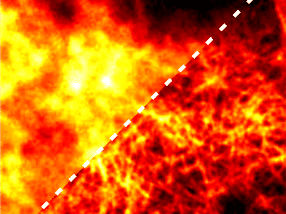
Seismologists have produced for the first time a sharp, three-dimensional scan of Earth's interior that conclusively connects plumes of hot rock rising through the mantle with surface hotspots that generate volcanic island chains like Hawaii, Samoa and Iceland.
Essentially a computed tomography, or CT scan, of Earth's interior, the picture emerged from a supercomputer simulation at the Department of Energy's National Energy Research Scientific Computing Center (NERSC) at the Lawrence Berkeley National Laboratory.
While medical CTs employ X-rays to probe the body, the scientists mapped mantle plumes by analyzing the paths of seismic waves bouncing around Earth's interior after 273 strong earthquakes that shook the globe over the past 20 years.
Previous attempts to image mantle plumes have detected pockets of hot rock rising in areas where plumes have been proposed, but it was unclear whether they were connected to volcanic hotspots at the surface or the roots of the plumes at the core mantle boundary 2,900 kilometers below the surface.
The new, high-resolution map of the mantle not only shows these connections for many hotspots on the planet, but reveals that below about 1,000 kilometers the plumes are between 600 and 1,000 kilometers across, up to five times wider than geophysicists thought. The plumes are likely at least 400 degrees Celsius hotter than surrounding rock.
"No one has seen before these stark columnar objects that are contiguous all the way from the bottom of the mantle to the upper part of the mantle," said first author Scott French, a computational scientist at NERSC who recently received his Ph.D. from UC Berkeley.
"These columns are clearly separated in the lower mantle and they go all the way up to about 1,000 kilometers below the surface, but then they start to thin out in the upper part of the mantle, and they meander and deflect," she said. "So while the tops of the plumes are associated with hotspot volcanoes, they are not always vertically under them."
Ancient anchors
The new picture also shows that the bases of these plumes are anchored at the core-mantle boundary in two huge blobs of hot rock, each about 5,000 kilometers in diameter, that are likely denser than surrounding rock. Romanowicz estimates that those two anchors - directly opposite one another under Africa and the Pacific Ocean - have been in the same spots for 250 million years.
"Tomography is the most powerful method to get this information, but in the future it will be combined with very sensitive gravity measurements from satellites and maybe electromagnetic sounding, where people do conductivity measurements of the interior," she said.
Original publication
Other news from the department science


Get the analytics and lab tech industry in your inbox
From now on, don't miss a thing: Our newsletter for analytics and lab technology brings you up to date every Tuesday. The latest industry news, product highlights and innovations - compact and easy to understand in your inbox. Researched by us so you don't have to.